Bing Maps gets its largest update to date – 165TB worth of aerial imagery
Bing Maps has received a huge update, amassing a total of 165 terabytes of information and imagery. This is the largest update to the mapping service ever and it’s larger than all of the past Aerial releases combined! To give you a little perspective the prior existing Aerial coverage of Bing Maps was 129 terabytes in total.
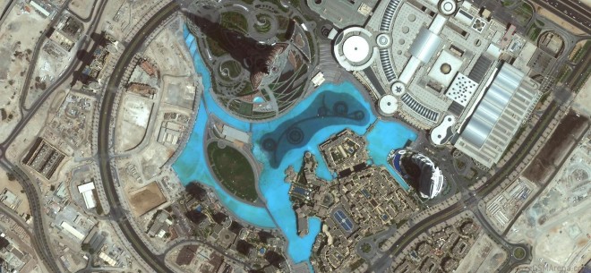
The update brings high-quality aerial photos of North America, South America, Africa, Australia, Europe and Asia with the total covered area being around 38 million square kilometers or roughly Russia’s land area multiplied by two plus the whole of India. Pretty impressive stuff.
The images were taken both by satellites and by special airplanes courtesy of the Global Ortho project.
Check out the Source link for detailed information and samples of the improvement.
Featured
 Oppo R7 battery life test
 Hot or Not: Android M, iOS 9 and Watch OS 2.0
 Lenovo A7000 Preview
 Xiaomi Mi 4i battery life test
 Benchmarking Asus ZenFone 2 ZE551ML with Intel Atom Z3580 SoC and 4GB of RAM
Categories
- Mobile phones
- Mobile software
- Mobile computers
- Rumors
- Fun stuff
- Various
- Android
- Desktop software
- Featured
- Misc gadgets
- Gaming
- Digital cameras
- Tablets
- iOS
- Desktop computers
- Windows Phone
- GSMArena
com - Online Services
- Mobile Services
- Smart Watches
- Battery tests
- BlackBerry
- Social Networks
- Web Browsers
- Portable Players
- Network Operators
- CDMA
- Windows
- Headphones
- Hands-on
Comments
Rules for posting