Apple changes and/or ditches Google Maps in iPhoto?
During the just iPad announcement yesterday we saw iPhoto migrate from a OS X-only to an iOS-capable app.
And while that on its own doesn’t deserve too much attention, the iPhoto maps integration is curious in that it no longer features Google’s Maps.
In iPhoto for Mac the Map interface (where you see your geo-tagged pics) is definitely Google Maps, but in the iOS version it looks nothing like it.
There’s been a lot of digging into the matter and some users are finding that the map data is actually coming from an Apple server gsp2.apple.com.
John Gruber of The Daring Fireball actually took it directly to Apple, which replied the data is coming from Google Maps.
So there’s no knowing what’s at play here – perhaps Apple is en route to introduce its own mapping service on iOS (and OS X) – they bought maps company Placebase, then and 2010 Google Earth rival Poly9 and finally, 3D mapping firm C3 Technologies in August 2010.
Interestingly, the map data for the Places tab in the Photos app still comes from Google Maps.
Maybe iPhoto is a way of testing out a new layout, maybe Apple (aware of the attention this will immediately attract) changed up the maps UI to send a clear message to Google, maybe collect thoughts on the new map design.
We’ll probably have to wait until iOS 6 to find out.
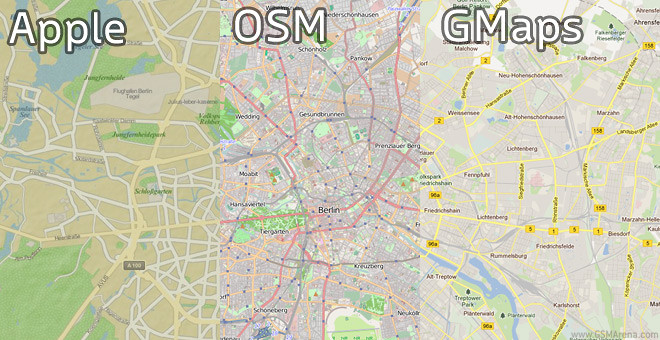
UPDATE: It seems that Apple is indeed using Open Source Maps but with a custom overlay of their own. This was confirmed by OSM in their official blog. And here’s a tool you can use to see the difference between Apple’s layout, OSM’s and Google Maps’s.
Featured
 Your verdict on Android M, iOS 9 and Watch OS 2.0
 Hot or Not: Android M, iOS 9 and Watch OS 2.0
 HTC One E9+ performance benchmarks
 Lenovo A7000 Preview
 Benchmarking Asus ZenFone 2 ZE551ML with Intel Atom Z3580 SoC and 4GB of RAM
Categories
- Mobile phones
- Mobile software
- Mobile computers
- Rumors
- Fun stuff
- Various
- Android
- Desktop software
- Featured
- Misc gadgets
- Gaming
- Digital cameras
- Tablets
- iOS
- Desktop computers
- Windows Phone
- GSMArena
com - Online Services
- Mobile Services
- Smart Watches
- Battery tests
- BlackBerry
- Social Networks
- Web Browsers
- Portable Players
- Network Operators
- CDMA
- Windows
- Headphones
- Hands-on
Comments
Rules for posting