Google Maps now deliver real-time public transit information
Beginning today, Google Maps will show you real-time transit information. The search giant has been providing transit information for a while now, though not in real-time.
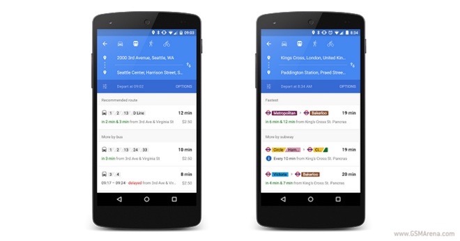
The feature will deliver live arrivals for buses, metro trains, and subway. Even cancelled routes will be displayed. Google has partnered with over 100 partners and 6,000 transportation authorities to deliver the goods.
Today, Google also added added 25 new partners in six locations for its project. They include the United Kingdom, Netherlands, Budapest, Chicago, and San Francisco among others.
Have you tried the new Google Maps functionality? Drop us a line with your thoughts in the comments below.
Featured
 Lenovo A7000 Preview
 Your verdict on Android M, iOS 9 and Watch OS 2.0
 HTC One M9+ preview
 Benchmarking Asus ZenFone 2 ZE551ML with Intel Atom Z3580 SoC and 4GB of RAM
 Oppo R1x battery life test
Categories
- Mobile phones
- Mobile software
- Mobile computers
- Rumors
- Fun stuff
- Various
- Android
- Desktop software
- Featured
- Misc gadgets
- Gaming
- Digital cameras
- Tablets
- iOS
- Desktop computers
- Windows Phone
- GSMArena
com - Online Services
- Mobile Services
- Smart Watches
- Battery tests
- BlackBerry
- Social Networks
- Web Browsers
- Portable Players
- Network Operators
- CDMA
- Windows
- Headphones
- Hands-on
Comments
Rules for posting